NIPPON CIVIC CONSULTING ENGINEERS CO., LTD. Site map Japanese
Home > Introducing Nippon Civic > Tokyo Bay Aqualine Tunnel  
Project
Urban Shield Tunnels
Submarine Shield Tunnels
Immersed Tube Tunnels
Tunnel Rehabilitation
  Tokyo Bay Aqualine Tunnel 
 

Location of Trans-Tokyo Bay HighwayOutline
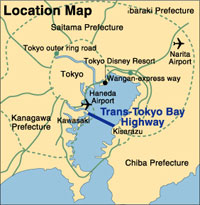
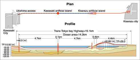
The Trans-Tokyo Bay Highway, also known as the Tokyo Bay Aqualine, is a 15.1 km marine crossing through the middle of Tokyo Bay connecting Kawasaki City in Kanagawa Prefecture with Kisarazu City in Chiba Prefecture on the Boso Peninsular. With the journey from Kawasaki to Kisarazu now taking just 15 minutes, the highway plays a vital economic role in integrating these two areas of prime industrial importance. The areas are otherwise separated by a 100-km journey through the heart of metropolitan Tokyo, so the Aqualine also eases traffic congestion in the broader metropolitan road network.

 
Technical Features
The Aqualine consists of a 9.5-km shield tunnel (the Tokyo Bay Tunnel) and a 4.4-km bridge from an artificial island to the Kisarazu landing. The tunnel diameter is the world's largest for an underwater shield tunnel used for motor vehicle traffic. The cross-section diameter to the outside of the segment lining is 13.9 m, and the inner diameter of 11.9 m provides for two lanes of traffic in both directions.
Plan & Profile of Trans-Tokyo Bay Highway
 
Segment lining of Trans-Tokyo Bay HighwayRole 
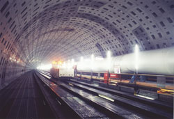
of NCC in tunnel construction
NCC designed the segment lining structure for the Aqualine tunnel. The design presented particular challenges due to the need to safeguard the tunnel against large ground and hydraulic pressures and prevent seawater leakage. Moreover, the seismic activity of the area meant that such protection needed to be earthquake proof. The long-bolt system was therefore used for assembling the lining segments, and special sealing measures were taken along the segment joints to make the tunnel lining impervious to seawater.


Copyright(c) 2005, Nippon Civic Consulting Engineers Co., Ltd.